
 As someone who has spent many years discovering, describing, and sharing GIS data and maps, my skills to actually create maps were in need of some help.
So, on Saturday afternoon at the Global Investigative Journalism Conference, I attended a two-session, hands-on workshop, “Mapping With Arc.” The session was described in the conference program as an introduction to “analyzing data for stories by using mapping software.”
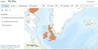
The workshop utilized ESRI’s ArcGIS Online Platform, which the company has generously made available to GIJN members and participants at the Global Conference.
The workshop was taught by two well-known and highly respected instructors, Andy Lehren of The New York Times and Jennifer LeFleur of the Center of Investigative Reporting in Berkeley, California.
Lehren and LeFleur shared a lot of knowledge in a short amount of time and did a remarkable job. Once a step was mastered, we repeated the process and added something new. Along with the “how to use” instruction, time was also spent discussing why you might want to map data in the first place.
Takeaways
- Shapefiles — a spatial data format that ArcGIS uses to create maps — are the most popular type of GIS data file.
- As is the case with all data used in an investigation, make sure to consider the credibility and sourcing of the data set used to generate the map.
- Consider reaching out to geography or digital mapping departments and university libraries to assist in finding data.
Links
The platform we learned in the workshop including plenty of documentation and instruction.
 Story Maps
A site to post and share maps created with ArcGIS. Provided by ESRI.
Dictionary of GIS Terms
Another ESRI resource. Understanding key terms is essential.
Database: ArcGIS Open
A free searchable database of more than 32,000 open data sets.
Database: SmartGov Africa
“SG Africa is now the largest single pan-African open data portal, with 1.2M datapoints already available, across 54 African countries.”
Database: PublicData.eu
Includes many shape files.
Some libraries offer what are known as LibGuides on many topics. Here are four examples that include hundreds of links to GIS data sources:
 Gary Price (gprice@mediasourceinc.com) is director of GIJN’s Resource Center and a librarian, writer, consultant, and frequent conference speaker. He is the author of INFOdocket (@infodocket) for Library Journal, and was a co-founder and senior editor at ResourceShelf and DocuTicker. He previously served as contributing editor to Search Engine Land and director of Online Information Services at Ask.com.
